


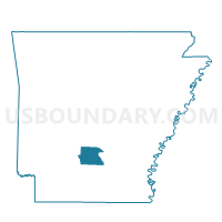
Voting District 6, Dallas County, Arkansas
About
Outline

Summary
| Unique Area Identifier | 526378 |
| Name | Voting District 6 |
| County | Dallas County |
| State | Arkansas |
| Area (square miles) | 270.28 |
| Land Area (square miles) | 270.26 |
| Water Area (square miles) | 0.02 |
| % of Land Area | 99.99 |
| % of Water Area | 0.01 |
| Latitude of the Internal Point | 34.06032900 |
| Longtitude of the Internal Point | -92.61392870 |
Maps


Graphs
Select a template below for downloading or customizing gragh for Voting District 6, Dallas County, Arkansas


Neighbors
Neighoring Voting District (by Name) Neighboring Voting District on the Map
- Voting District 7, Dallas County, AR
- Voting District 8, Dallas County, AR
- Voting District 9, Dallas County, AR
- Brown Springs Voting District, Hot Spring County, AR
- CALVERT Voting District, Grant County, AR
- Clear Creek Voting District, Hot Spring County, AR
- DAVIS Voting District, Grant County, AR
- East County Voting District, Clark County, AR
- Harrison Voting District, Hot Spring County, AR
- MADISON Voting District, Grant County, AR
- Saline Voting District, Cleveland County, AR
- TENNESSEE Voting District, Grant County, AR
- Whiteoak Voting District, Cleveland County, AR
Top 10 Neighboring County Subdivision (by Population) Neighboring County Subdivision on the Map
- Caddo township, Clark County, AR (22,995)
- Calvert township, Grant County, AR (1,344)
- Tennessee township, Grant County, AR (761)
- Madison township, Grant County, AR (713)
- Chester township, Dallas County, AR (430)
- Manchester township, Dallas County, AR (415)
- Clear Creek township, Hot Spring County, AR (392)
- Davis township, Grant County, AR (359)
- Holly Springs township, Dallas County, AR (314)
- Southall township, Dallas County, AR (303)
Top 10 Neighboring Place (by Population) Neighboring Place on the Map
Top 10 Neighboring Unified School District (by Population) Neighboring Unified School District on the Map
- Sheridan School District, AR (25,888)
- Malvern Special School District, AR (18,325)
- Arkadelphia School District, AR (16,268)
- Fordyce School District, AR (5,722)
- Cleveland County School District, AR (5,521)
- Harmony Grove School District, AR (5,284)
- Ouachita School District, AR (1,992)
Top 10 Neighboring State Legislative District Lower Chamber (by Population) Neighboring State Legislative District Lower Chamber on the Map
- State House District 10, AR (27,718)
- State House District 19, AR (27,250)
- State House District 18, AR (27,129)
- State House District 20, AR (26,358)
- State House District 8, AR (25,029)
Top 10 Neighboring State Legislative District Upper Chamber (by Population) Neighboring State Legislative District Upper Chamber on the Map
- State Senate District 27, AR (81,170)
- State Senate District 23, AR (75,803)
- State Senate District 26, AR (68,899)
Top 10 Neighboring 111th Congressional District (by Population) Neighboring 111th Congressional District on the Map
Top 10 Neighboring Census Tract (by Population) Neighboring Census Tract on the Map
- Census Tract 9539, Clark County, AR (5,472)
- Census Tract 205, Hot Spring County, AR (5,047)
- Census Tract 4701, Grant County, AR (5,008)
- Census Tract 9701, Cleveland County, AR (4,895)
- Census Tract 4703, Grant County, AR (3,994)
- Census Tract 4702, Grant County, AR (3,197)
- Census Tract 9702, Dallas County, AR (1,887)
- Census Tract 9701, Dallas County, AR (1,564)
Top 10 Neighboring 5-Digit ZIP Code Tabulation Area (by Population) Neighboring 5-Digit ZIP Code Tabulation Area on the Map
- 72104, AR (23,354)
- 71923, AR (15,637)
- 72150, AR (12,006)
- 71665, AR (6,054)
- 71742, AR (5,980)
- 71720, AR (2,498)
- 71941, AR (2,098)
- 71763, AR (1,666)
- 72084, AR (1,229)
- 71652, AR (1,159)